Prospective metro-centric redesign of Marseille’s transit network
 MetroDreamin'
Prospective metro-centric redesign of Marseille’s transit network (March - August 2025)
In March 2025, I had the idea to carry out a comprehensive prospective extension study of the Marseille transport network.
With this in mind, I took a map created by another user representing lines 1 and 2 of the Marseille metro, and I started with an extension of the two main lines.
Presentation of the extension project
Vision and goal
This project is a transport utopia based mainly on massive metro usage. Indeed, I consider that tramway extensions within the city are not the way forward given its substantial size, which considerably slows down travel, especially when considering connections from other municipalities in the Marseille suburbs.
However, it is largely fictional as it does not include the current tramway network, or only partially (from Sainte-Marguerite to La Gaye), but it shows what a good network for the city could look like.
I am going to restart this project from scratch, also taking into account the tramway and its extensions, in order to propose a more realistic and applicable vision.
However, I am well aware of the political and economic realities that slow down this type of project; also, this one concerns the suburbs of the city (even the nearby ones) very little or not at all, although these were explored in my Marseille RER (commuter rail) project.
Overview of lines
| Line Number | Type | Terminus | Number of stations | Length | Duration | Particularities |
|---|---|---|---|---|---|---|
| 1 | Heavy Metro | Val de Gray P+R - Les Trois Lucs | 25 | 19 km | 28 min | Park & Ride on undeveloped land at Val de Gray |
| 2 | Heavy Metro | Hôpital-Nord - Campus de Luminy | 28 | 22 km | 32 min | Branched operation with line 2bis, doubled frequency on the central section |
| 2bis | Heavy Metro | Grande Campagne - Bonneveine | 38 | 29 km | 41 min | Common section with line 2, operated as a branch |
| 3 | Light Metro / Tramway | Plages du Prado-Le David - La Valentine | 17 | 11 km | 18 min | Would include tunnel sections (Rond-Point du Prado), viaduct sections (Ste-Marguerite), and tramway sections |
| 4 | Heavy Metro | Departures from Gèze | 30 | 28 km | 40 min | Circular line to optimize connections, constructed via cut-and-cover on the major part |
| 5 | Heavy Metro | Sainte Marthe - Montredon | 18 | 14 km | 21 min | Short trainsets with two cars (like the Lyon metro) |
| 6 | Heavy Metro | L'Estaque - Le Redon | 21 | 18 km | 26 min | Short trainsets with two cars (like the Lyon metro) |
| 7 | BRT | La Calade - La Valentine | 36 | 17 km | 33 min | Orbital line to connect the Eastern districts of the city |
| 8 | Heavy Metro | Les Olives - Le Pharo | 19 | 9.4 km | 15 min | Short trainsets with two cars (like the Lyon metro) |
| 9 | BRT | Hôpital Nord - Saint-Charles | 15 | 9.2 km | 17 min | Located along the A7 highway, improves the mesh of the Northern districts |
| 10 | Tramway | Castellane - Rouvière | 12 | 5 km | 10 min | Improves the mesh of the Southern districts |
| 11 | BRT | Estrangin-Préfecture - Rouvière | 20 | 7.5 km | 15 min | Improves the mesh of the center and Southern districts |
Line by line
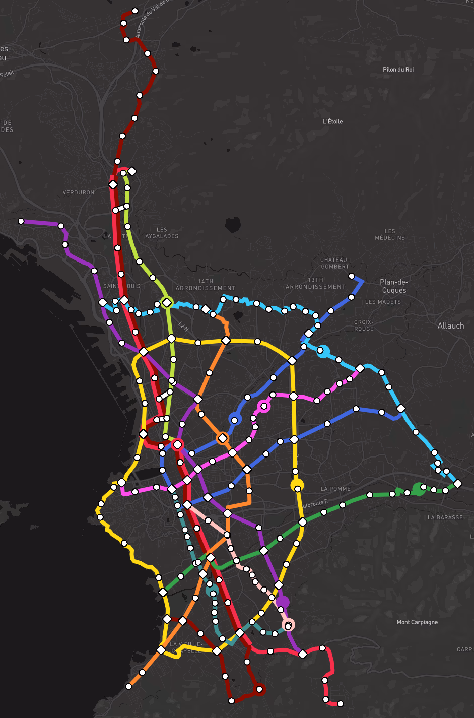
Line 1
Line 1 is a rubber-tyred heavy metro line inaugurated in 1977 which connects, in this project, the Val de Gray Park & Ride to Les Trois-Lucs. The new line 1 connects with all network lines, except line 3.
For this line, I created two extensions:
Extension to Val de Gray
I extended the line with three additional stations, which improve service to the Saint-Jérôme university site, Château-Gombert, and Plan-de-Cuques. A Park & Ride at the terminus, which would be located on currently undeveloped land (near the hamlet of Val de Gray), would improve last-mile service for residents located too far to walk to the metro.
The neighborhoods located at the level of this extension are not fully built up, and the extension could be partially financed by real estate projects along the line's route (housing, offices, shopping centers...).
Extension to Les Trois-Lucs
The line has been extended to the Monique Gallician roundabout, in the eastern district of Les Trois-Lucs, improving service to the Western districts, particularly the Saint-Julien district.
This extension would be carried out in a semi-deep tunnel up to Saint-Julien, then in a cut-and-cover trench starting from Avenue Fernandel.
Line connections
The line connects with:
- Line 2, 2bis: Saint-Charles, Castellane
- Line 4: La Fourragère
- Line 5: Cinq Avenues-Longchamp, La Blancarde
- Line 6: Baille
- Line 7: La Rose, Les Trois Lucs
- Line 8: Estrangin-Préfecture
- Line 9: Saint-Charles, Baille
- Line 10: Castellane
- Line 11: Estrangin-Préfecture
Lines 2 and 2bis
Line 2 is a rubber-tyred heavy metro line inaugurated in 1984 which connects, in this project, Hôpital Nord to the Luminy Campus. It operates as a branched service with line 2bis on a central section, which allows for double frequency in the heart of the city.
The Sainte-Marguerite-Dromel viaduct has been detached from it to be taken over by the light metro line 3.
Trips mixing the branches could be envisaged; for example, by running Grande Campagne - Campus de Luminy services.
Line 2
Extension towards Hôpital Nord
Since transport networks up to Hôpital Nord are insufficient, the metro has been extended there, complementing the BRT line 9.
In my vision, this extended line would allow for advanced opening up (désenclavement) of the northern and southern districts of the city, which are poorly connected to the heavy transport network.
This extension allows for vastly improved service to the northern districts and the 15th arrondissement, serving the dense Saint-Antoine neighborhood as well as the Grand Littoral shopping center, which could create a new economic breath for the area.
Extension towards Campus de Luminy
Replacing the B1 bus line, I imagined an extension of line 2 from the Rond-Point du Prado to the Luminy Campus. This could be constructed in a cut-and-cover trench under the existing roadway and would serve a very busy axis of the southern districts. A Park & Ride could be envisaged at the North of Luminy, to serve residents of surrounding municipalities (Cassis, Carnoux-en-Provence...).
Line connections
The line connects with:
-
Line 1: Saint-Charles, Castellane
-
Line 2bis: Common route from Saint-Antoine - Village to Rond-Point du Prado
-
Line 3: Rond-Point du Prado
-
Line 4: Gèze, Joliette, Obélisque
-
Line 5: Rond-Point du Prado
-
Line 6: Gèze, Saint-Charles, Le Redon
-
Line 7: Rue de Lyon
-
Line 8: Notre-Dame du Mont
-
Line 9: Hôpital Nord, Saint-Charles
-
Line 10: Castellane
-
Line 11: Obélisque
Line 2bis
Line 2bis is a rubber-tyred heavy metro line that shares its central section with line 2. It serves the city on a South-West - North axis, connecting Grande-Campagne (Cabriès) to the Bonneveine district and its beaches.
Extension towards Grande Campagne
This extension allows for fine-grained service to Septèmes-les-Vallons, as well as the Plan-de-Campagne commercial zone, a large economic activity basin that could evolve towards a more virtuous model less centered on the car.
Extension towards Bonneveine - Plage
The extension of the line towards Bonneveine beach allows for optimal service to the southernmost districts of the city, excluding Callelongue and Les Goudes.
Line connections
The line connects with:
-
Line 1: Saint-Charles, Castellane
-
Line 2: Common route from Saint-Antoine - Village to Rond-Point du Prado
-
Line 3: Rond-Point du Prado
-
Line 4: Gèze, Joliette, Obélisque, Hambourg, Bonneveine - Plage
-
Line 5: Louis Bonnefon, Rond-Point du Prado
-
Line 6: Gèze, Saint-Charles
-
Line 7: Rue de Lyon
-
Line 8: Les Olives, from Saint-Antoine to Joliette, Noailles, Notre-Dame du Mont, Obélisque
-
Line 9: Gare de Saint-Antoine, Les Aygalades, Désirée Clary - Kleber, Saint-Charles
-
Line 10: Castellane
-
Line 11: Périer, Obélisque
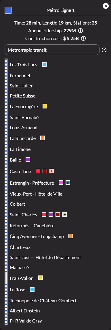
Line 3
This hybrid line between light metro and tramway follows an east-west axis from Plages du Prado to La Valentine and its vast commercial zone. It alternates underground sections, entirely separated from the roadway, with viaduct sections to adapt to the complex topography of the Huveaune valley, which the line follows closely.
It also allows for fine-grained service to the Saint-Loup and Saint-Marcel districts.
Line connections
The line connects with:
-
Line 2, 2bis: Rond-Point du Prado
-
Line 4: Plages du Prado - Le David, Saint-Loup
-
Line 5: Rond-Point du Prado
-
Line 6: Romain Rolland
-
Line 7: La Valentine
-
Line 10: Sainte-Marguerite Dromel
Line 4
Line 4 is a circular (loop) rubber-tyred heavy metro line. Its purpose is to connect peripheral districts to each other without passing through the hyper-center, thus optimizing the global mesh of the network and connections. Its main regulation point is located at Gèze, where its depot would be situated.
A true complete belt, it would help fluidify complex journeys that take place outside the Marseille hyper-center.
Line connections
The line connects with:
-
Line 1: La Fourragère
-
Line 2: Gèze, Joliette, Obélisque
-
Line 2bis: Gèze, Joliette, Obélisque, Hambourg, Bonneveine - Plage
-
Line 3: Saint-Loup, Plages du Prado - Le David
-
Line 5: Saint-Pierre, Le Merlan, Pointe-Rouge
-
Line 6: Gèze, Régny
-
Line 8: Joliette, Le Pharo, Montolivet
-
Line 10: La Gaye
-
Line 11: Obélisque
Line 5
Line 5 is a metro line operated with short trainsets (Lyon metro type or lighter VAL type). It connects Sainte-Marthe in the north to Montredon in the south, offering fine-grained service to residential neighborhoods.
It connects Montredon to Sainte-Marthe and its SNCF station on a south-east axis, serving several points of interest such as the Merlan shopping center, the Friche de la Belle de Mai venue, or the Gare de la Blancarde.
Line connections
The line connects with:
-
Line 1: Cinq Avenues - Longchamp, La Blancarde
-
Line 2, 2bis: Rond-Point du Prado, Louis Bonnefon (2bis only)
-
Line 3: Rond-Point du Prado
-
Line 4: Le Merlan, Saint-Pierre, Pointe-Rouge
-
Line 6: Place de Pologne, Plombières
-
Line 7: Sainte-Marthe
-
Line 8: Sakakini
-
Line 10: Rabatau, Saint-Giniez
Line 6
Line 6 is a metro line with short trainsets connecting L'Estaque to Le Redon. It traverses the city from northwest to southeast, serving important hubs like the Saint-Charles station and points of interest like La Plaine.
Line connections
The line connects with:
-
Line 1: Saint-Charles, Baille
-
Line 2: Gèze, Saint-Charles, Le Redon
-
Line 2bis: Gèze, Saint-Charles
-
Line 3: Romain Rolland
-
Line 4: Gèze, Régny
-
Line 5: Plombières, Place de Pologne
-
Line 7: La Calade
-
Line 8: La Plaine
-
Line 9: Saint-Charles
-
Line 10, 11: Rouvière
Line 7
Line 7 is a Bus Rapid Transit (BRT) line operating as an orbital route. It connects La Calade to La Valentine, connecting the Eastern and Northern districts without passing through the city center.
Line connections
The line connects with:
-
Line 1: La Rose, Les Trois Lucs
-
Line 2, 2bis: Rue de Lyon
-
Line 3: La Valentine
-
Line 5: Sainte-Marthe
-
Line 6: La Calade
Line 8
Line 8 is a heavy metro line with short trainsets connecting Les Olives to Le Pharo. It offers a rapid east-west link traversing dense neighborhoods like Saint-Victor and Le Camas, and less dense neighborhoods such as Montolivet.
Line connections
The line connects with:
-
Line 1: Estrangin - Préfecture
-
Line 2, 2bis: Notre-Dame du Mont
-
Line 4: Montolivet, Le Pharo
-
Line 5: Sakakini
-
Line 6: La Plaine
-
Line 11: Estrangin - Préfecture
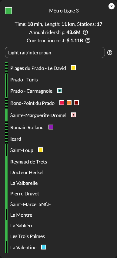
Line 9
Line 9 is a BRT line running along the A7 highway. Its goal is to improve the mesh of the Northern districts and quickly connect Hôpital Nord to the Saint-Charles station by allowing traffic alleviation and offering another transport perspective to the Northern districts.
It would be arranged along the A7 for most of the route, with stations in the manner of the Briis-sous-Forges highway bus station on the A10 in the Paris region.
Line connections
The line connects with:
-
Line 1: Saint-Charles
-
Line 2: Hôpital Nord, Saint-Charles
-
Line 2bis: Saint-Charles
-
Line 4: Les Arnavaux
-
Line 6: Bon-Secours, Saint-Charles
-
Line 11: Zodiaque
Line 10
Line 10 is a tramway line connecting Castellane to Rouvière. It allows for densifying the mesh of the Southern districts and decongesting the major road axes of this zone.
It densifies the transport network in the Southern districts, particularly the Sainte-Marguerite district, which is very dense and poorly connected to heavy transport apart from this line.
Line connections
The line connects with:
-
Line 1: Castellane
-
Line 2, 2bis: Castellane
-
Line 3: Sainte-Marguerite Dromel
-
Line 4: La Gaye
-
Line 5: Rabatau
-
Line 6: Rouvière
-
Line 11: Rouvière
Line 11
Line 11 is a BRT line connecting Estrangin-Préfecture to Rouvière. It completes the mesh of the city center and offers a transport alternative towards the southern districts.
Line connections
The line connects with:
-
Line 1: Estrangin - Préfecture
-
Line 2, 2bis: Périer, Obélisque
-
Line 4: Obélisque
-
Line 6: Rouvière
-
Line 8: Estrangin - Préfecture
-
Line 10: Rouvière
Gallery
Screenshot from the website showing the complete map